
Haridwar Kumbh 2027 · Official map
The Official Haridwar Kumbh 2027 Map: How to Use It
The official map is the Interactive Mela Map on the Haridwar Kumbh website, at haridwarkumbh.uk.gov.in/map-and-traffic-updates. On 18 October 2026 it showed 1,758 places in 23 categories, the 32 mela sectors in five zones, and a separate Proposed Sector Plan of 351 points, including 9 lost-and-found centres and 24 parking points.
Read on the official map by the KumbhMela.info Editorial Team on 18 October 2026. The site is new and its data can change; the Proposed Sector Plan is a plan, not a notified arrangement.
This page explains what each layer shows, which parts are proposed, and how to open the map on a phone. It describes the map only. On bathing days, follow police and mela instructions.
The map at a glance
| What | Detail |
|---|---|
| Address | https://haridwarkumbh.uk.gov.in/map-and-traffic-updates |
| Published by | Haridwar Kumbh Mela administration, Government of Uttarakhand, on the official website launched on 12 October 2026 |
| How the site links to it | “Traffic Plan” at the top of the page, “Kumbh Map” under Quick Links at the foot of every page |
| Places shown when it opens | 1,758, in the GIS Layers group |
| Sectors | 32, numbered 1 to 32, in five zones |
| Proposed Sector Plan | 351 planned points; switched off when the map opens |
| Base map | Map or Satellite |
| Directions | “Get Directions” opens Google Maps |
| Traffic plan | Not on the page on 18 October 2026 |
| Checked | 18 October 2026 |
 Screenshot of the official Haridwar Kumbh 2027 website (haridwarkumbh.uk.gov.in), 20 Oct 2026. Numbers added by KumbhMela.info
What the GIS layers show
The GIS Layers group is what the map shows when it first opens. Its places carry no “proposed” label in the map’s data. It has three outlines (Outer boundary, Land use and Sector outline) and 23 categories of places. The four largest are below, with the full list after them.
Go deeperAll 23 layers and their counts1 min read
| Layer | Places |
|---|---|
| Akharas | 102 |
| Ashrams | 89 |
| ATMs | 225 |
| Banks | 75 |
| Bus stations | 5 |
| Chowks | 28 |
| Dharmshalas | 204 |
| EV charging stations | 35 |
| Fire stations | 2 |
| Forest check posts | 1 |
| Forest chowkis | 1 |
| Ghats | 115 |
| Government offices | 38 |
| Hospitals | 11 |
| Medical stores | 114 |
| Hotels | 609 |
| Kutiyas | 5 |
| Parks | 9 |
| Petrol pumps | 18 |
| Police stations | 10 |
| Post offices | 19 |
| Public toilets | 20 |
| Temples | 23 |
| Total | 1,758 |
The ghats layer lists 115 ghats. Our Haridwar ghats guide explains the main ones, their traditions and where they are.
The 32 sectors and five zones
The mela area is divided into 32 numbered sectors, which the map groups into five zones. The official site uses these sector names and numbers to say where a place is, for example in its lost-and-found directory. The map’s sector picker lets you show one sector at a time.
| Zone | Sectors (number) |
|---|---|
| Ranipur Zone | Bahadrabad (1), Jwalapur (2), Ranipur (3) |
| Bairagi Camp Zone | Mayapur (4), Daksh Dweep (5), Belwala (6), Rodi (8), Kankhal (10), Bairagi Camp (11), Sati Dweep (12), Haridwar (21) |
| Gauri Shankar Zone | Gauri Shankar (7), Neeldhara (9), Chandi Devi (20) |
| Pant Dweep Zone | Pant Dweep (13), Lalji Wala (14), Bhopatwala (15), Kangra Dweep (16), Bheemgoda (17), Saptsarovar (18), Mansa Devi (19), Har Ki Pauri (22), Motichur (24) |
| Rishikesh Zone | Swargashram (23), Muni Ki Reti (25), Rishikesh (26), Chandrabhaga (27), Raiwala (28), Shyampur (29), Laxman Jhula (30), Chila (31), Neelkanth (32) |
The map spells some names differently, for example HARKIPAUDI-22 and BAIRAGICAMP-11. We use the usual spelling with the official number.
The Proposed Sector Plan: official, but not final
The second group of layers is called Proposed Sector Plan. It is published by the mela administration, so it is official, but every point in it is marked “proposed” in the map’s data and carries no date or notice number. Treat it as a plan. When you switch it on, the map hides the GIS place layers; the button says so.
Go deeperAll 18 proposed layers and their counts1 min read
| Proposed layer | Points |
|---|---|
| Police stations | 123 |
| Hospitals | 52 |
| Fire stations | 32 |
| Parking | 24 |
| Sanitation | 20 |
| Public toilets | 19 |
| Drinking water | 16 |
| Food courts | 14 |
| Akharas | 12 |
| Lost and found | 9 |
| Temples | 9 |
| Bus stations | 7 |
| Dharmshalas | 6 |
| Ghats | 3 |
| Veterinary | 2 |
| Gas agency | 1 |
| Post offices | 1 |
| Railway | 1 |
| Total | 351 |
Lost-and-found centres
Nine points, one in each of these sectors: Jwalapur (2), Ranipur (3), Daksh Dweep (5), Belwala (6), Neeldhara (9), Bairagi Camp (11), Pant Dweep (13), Lalji Wala (14) and Saptsarovar (18). The site’s Lost and Found directory and its Safety and Emergency page list the same centres by sector. None of them gives a phone number, an opening date or hours, so treat them as planned centres until the mela administration announces otherwise.
Parking points
24 points, labelled Parking, Parking Road, Internal Parking, VIP Parking and Reserved Area. Bahadrabad (1), Ranipur (3) and Daksh Dweep (5) have three each. Gauri Shankar (7), Pant Dweep (13), Lalji Wala (14), Bhopatwala (15), Bheemgoda (17), Saptsarovar (18), Swargashram (23), Motichur (24), Muni Ki Reti (25), Rishikesh (26), Chandrabhaga (27), Raiwala (28), Shyampur (29) and Laxman Jhula (30) have one each, and one more is marked “Paripheral”. The map gives no fee, capacity or timing for any of them, and the site had published no parking or traffic notice by 18 October 2026.
Akhara camps and other points
Proposed religious camping points for the akharas sit in Gauri Shankar (7), with a reserved area for akhara chariots in Rodi (8). The plan also marks three proposed ghats, in Pant Dweep (13), Neeldhara (9) and Kangra Dweep (16).
How to open the map on a phone
The map needs a data connection. We found no downloadable or printable version of it on the site on 18 October 2026.
- Open the map pageOpen haridwarkumbh.uk.gov.in/map-and-traffic-updates in your phone’s browser. You can also scroll to the foot of any page on the site and tap Kumbh Map. The site needs JavaScript; with it switched off, the page is blank.
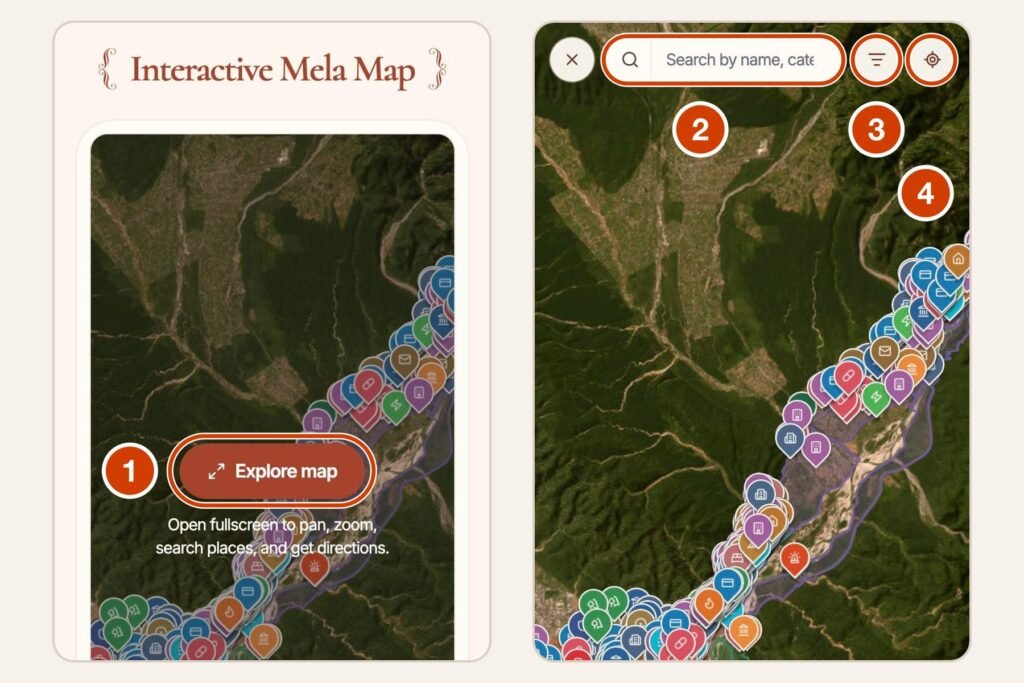
- Go full screenTap Explore map to open the map full screen.
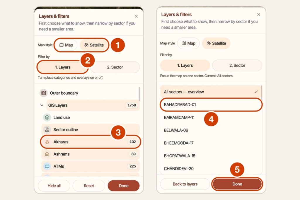
- Choose layers and a sectorTap the filter button at the top to open Layers & filters. Choose Map or Satellite, then 1. Layers to switch categories on or off and 2. Sector to show one sector. Tap Done.
- See the planned pointsTo see the planned points, turn on Proposed Sector Plan in the layers list. The count at the bottom changes from 1,758 to 351 places.
- Search for a placeType in the search box to find a place by name, category or address. Typing “Lost” lists the lost-and-found centres.
- Get directionsTap a place to see its details, then Get Directions to open the route in Google Maps.
- Find places near youThe location button (Near Me on a computer) asks for your phone’s location to show places near you. You can say no and still use the map.
 Screenshot of the official Haridwar Kumbh 2027 website (haridwarkumbh.uk.gov.in), 20 Oct 2026. Numbers added by KumbhMela.info
Where to check for updates
- The map page itself. The site’s “Traffic Plan” link opens it. On 18 October 2026 it showed the map only.
- Important Documents (haridwarkumbh.uk.gov.in/important-documents). On 18 October 2026 it listed five documents: two lists of Kumbh works and three reports on past melas. None was a map or traffic notice.
- Snan and Events on the same site, for the bathing days. Our Haridwar Kumbh 2027 guide has the dates and what each day means.
- The Haridwar district website, haridwar.nic.in, which links to the Kumbh site.
- Our Haridwar Kumbh 2027 updates page, where we log each official change with its date and source.
For every official Kumbh website, app and helpline in one place, see Official Kumbh websites, apps and helplines.
What the map does not show
- Live information. The map shows fixed points, with no live traffic layer and no timings.
- Routes for bathing days, road closures or diversions. None had been published on the official site by 18 October 2026.
- Which ghats will be open to the public on each bathing day.
- Fees for parking or anything else.
Follow police and mela instructions on the day.
A simpler map of the main places
The official map shows the sectors and zones. This simpler map, which we drew from OpenStreetMap, shows only the main ghats, temples, the railway station and the bus stand. It is not the official plan.
- 1Har Ki Pauri and BrahmakundGhat · Main bathing ghat
- 2Mansa Devi TempleTemple
- 3Chandi Devi TempleTemple
- 4Maya Devi TempleTemple
- 5Daksh Mahadev Temple, KankhalTemple
- 6Haridwar railway stationRailway
- 7Haridwar Roadways bus stationBus
A guide to where places are, not a route plan. During the mela, roads and ghats open and close by the official plan; follow police and mela directions. How to use the official Haridwar map.
Map data © OpenStreetMap contributors (ODbL). Some temple locations from Wikidata (CC0). openstreetmap.org/copyright
Questions people ask
Where are the lost-and-found centres?
The map’s Proposed Sector Plan has nine, in Jwalapur (2), Ranipur (3), Daksh Dweep (5), Belwala (6), Neeldhara (9), Bairagi Camp (11), Pant Dweep (13), Lalji Wala (14) and Saptsarovar (18). They are marked proposed, and no phone numbers or opening dates were given on 18 October 2026.
Does the official map show the traffic plan?
Not yet. The site’s “Traffic Plan” link opens the map, but on 18 October 2026 no traffic plan, diversion or parking notice had been published.
Can I use the map offline?
We found no offline or printable version on the official site on 18 October 2026. The map needs a data connection and a browser with JavaScript.
Sources
11 sources · checked 18 Oct 2026
- Interactive Mela Map, Haridwar Kumbh 2027 official website: layers, counts and controls · Haridwar Kumbh Mela administration, Government of Uttarakhand ·
- Points data file loaded by the Haridwar Kumbh 2027 Interactive Mela Map (all.geojson) · Haridwar Kumbh Mela administration, Government of Uttarakhand ·
- Sector boundaries data file loaded by the Haridwar Kumbh 2027 Interactive Mela Map · Haridwar Kumbh Mela administration, Government of Uttarakhand ·
- Map and Traffic Updates: Kumbh sectors and proposed akhara camping areas (Haridwar Kumbh 2027 official website) · Haridwar Kumbh Mela administration, Government of Uttarakhand ·
- Lost and Found Centers directory, Haridwar Kumbh 2027 official website · Haridwar Kumbh Mela administration, Government of Uttarakhand ·
- Safety and Security page, Haridwar Kumbh 2027 official website (re-checked 18 October 2026) · Haridwar Kumbh Mela administration, Government of Uttarakhand ·
- Haridwar Kumbh 2027 official website: home page, menu and footer (re-checked 18 October 2026) · Haridwar Kumbh Mela administration, Government of Uttarakhand ·
- Important Documents, Haridwar Kumbh 2027 official website (re-checked 18 October 2026) · Haridwar Kumbh Mela administration, Government of Uttarakhand ·
- District Haridwar, Government of Uttarakhand: home page and helpline page · District Administration, Haridwar (hosted by National Informatics Centre) ·
- Haridwar Kumbh 2027: सीएम धामी ने लॉन्च किया कुंभ का लोगो, वेबसाइट और गीत, जानें क्या है खास · Navbharat Live ·
- Snan and Events: Haridwar Kumbh 2027 (official website) · Haridwar Kumbh Mela administration, Government of Uttarakhand ·